    By
Bus and Boot (or maybe by car/bike and boot)
|
|
The Cowichan Valley
offers
fabulous opportunities for walking, nature viewing, and hiking.
Below we have identified the best nature outings available from our
transit routes. We hope this information will encourage
both visitors and local residents both to enjoy the outdoors and ride
our buses. Of course, these areas can also be enjoyed after
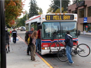
travelling by bicycle or automobile and you can even carry your bicycle
on a bus -- maps
of the bus routes are
available here.
|
| Maple
Bay (Bus route 4) |
|
The Maple Bay
bus (route 4) provides
service from downtown Duncan to Maple Bay and the subdivisions south
of Maple Bay Road. It provides access to hiking trails on Mount
Tzouhalem and Maple Mountain, the beach at Maple Bay, and two
protected Garry Oak meadows. The bus mostly goes in a loop. There
are 7
buses per day, Monday to
Friday, and fewer buses on Saturday. On Sunday, there is currently
not enough bus service to make hiking enjoyable. Bus schedules are
available at http://www.busonline.ca/regions/cow/schedules/schedule.cfm Mount Tzouhalem
What you will
find
Near the beginning of the trail is the Mount Tzouhalem Ecological Reserve, a hillside covered in Garry Oaks with amazing wildflowers in the spring. Because this is an ecologically sensitive area, it is recommended that hikers stay outside the fence most of the year. Except when the flowers are in bloom, there is little to experience that cannot also be found outside the fence. When viewing the flowers in the spring, stay on the trails. There is an interpretive kiosk at the entrance to the Ecological Reserve. Just beyond the Ecological Reserve are a number of bluffs with views of the Cowichan Valley, then a network of trails through the woods to views of the Cowichan Estuary and (on clear days) the Saanich Peninsula and some Gulf Islands and San Juan Islands. One bluff has a cross which was erected by St. Anne’s School, now Providence Farm. It is possible to hike from the top of the mountain to Tzouhalem Road, but there is no bus service at that end. More information and trail maps are available at http://www.northcowichan.bc.ca/siteengine/activepage.asp?PageID=144 Difficulty Access Maple
Bay Beach What you will
find
Maple Bay is a long shingle beach with interesting rock formations at either end. At high tide there is very little beach, so it is best to visit at other times. Click here for tide predictions for Maple Bay. The bay includes a small public dock, a boat launch, and a small park with a swimming float in the summer. The Maple Bay Rowing Club is next to the boat launch. The view of Saltspring Island from the Maple Bay waterfront is spectacular. Artist Tony Only painted many watercolours of this view. Difficulty Access Maple Mountain What you will
find
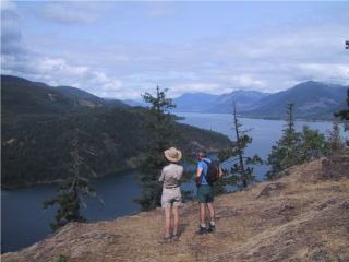
A network of steep trails through mixed forest above the shore of Sansum Narrows and to the summit of Maple Mountain. The views are spectacular and in the spring the wildflowers on the sunny slopes are magnificent. It is possible to hike to Crofton or to the municipal forest entrance on Osborne Bay Road. More information and trail maps can be found at http://www.northcowichan.bc.ca/siteengine/activepage.asp?PageID=144 Difficulty Access Cowichan Garry
Oak
Preserve
What you will
find
This extensive lowland Garry Oak meadow was purchased by the Nature Conservancy of Canada and the Cowichan Community Land Trust, a member of Nature Cowichan. It is a research and preservation facility so except for a few special events it is not open to the public. However, it is possible to view the meadow from a viewing platform on Maple Bay Road near McKenzie Road or by walking along Aitken Road at the west end of the Preserve. The wildflowers in the spring are a wonder, but all year this is a great place to look at native vegetation and observe birds and insects. Watch www.naturecowichan.net for announcements of volunteer days and special events at the Preserve. Difficulty Access |
back to top Last update March 2008. website email |